
![]()
Since 1988 I have been a weather watcher from my home in Galena Forest and now Montreux located in the Carson Range of the Sierra Nevada mountains near Reno, Nevada. Our current location is about 700 ft. lower in elevation but in the same general area. My interest in the weather dates back to my childhood when I am told I would pretend to be the TV weatherman. My years of flying as an instrument rated pilot increased my interest since many times correct weather interpretation kept my family and me alive. As an avid skier I am always interested in the storms that produce the heaven like powder snow we love to play in.
Over the years I found there are lots of folks interested in the same thing. Long range forecasting is my main interest, and it seems that local weather people are very hesitant to forecast very long range ( more than five days). Hence, I decided to begin sending an e-mail to my friends who shared the common interest or just wanted to plan sick days off around big snow dumps. Updates are posted every few days as weather predictions change during the active weather months. From June through September updates are seldom. Daily updates are found on our weather station site noted below. - Randy York
________________________________________________________________________________________________________________________________________________________________________
March 27, 2025
It has been a long time since I last posted this blog, January 30th. I guess I haven't been very motivated since for the most part our Winter was unremarkable. Although we are near average with snow pack in the Carson Range of the Sierra, it didn't present itself much in the way winter usually does. I only used my snow blower once this season, I was away when we had the only storm that produced a foot of snow at our elevation, and it had melted by the time we returned. That hits on this point, we had a very warm winter with most of the snow at 6500 ft. and above. The statistics won't be published until mid April, we will update you when they come out.
Over the next week we will likely have the last winter type storm of the season. Yes, it is officially Spring, but we all know that here in Northern Nevada the date doesn't mean much weather wise. This series of storms has some punch as witnessed by the 123 mph gusts on Slide Mountain early this morning. Here are some details.
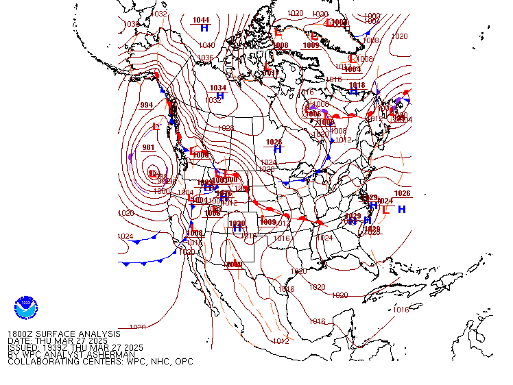
This graphic shows surface pressure. Low pressure depicted as red and High pressure as blue. If your interested in learning how to read weather maps you can Click Here. This map shows the surface position of the parent low off the coast of Oregon with a pressure of 981 mb or a barometer reading at 28.96 which is quite low, or in other words strong. This Parent low will be responsible for spinning off a series of fronts (the blue lines with points) over the next week or so. The current front is what brought the strong winds and now some showers, mainly in the Sierra today.
The next graphic is the forecast for clouds and precipitation for Friday at 10 AM. Most of the precipitation will have moved north and we will just have some clouds which should dissipate in the afternoon. Temperatures have cooled on the back side of the Front, Reno will remain in the mid 50's. Saturday looks to be a nice day with mostly sunny skies with cool temperatures like Friday. Winds should be light.
The next Front approaches Sunday afternoon with a good amount of moisture and wind. The forecast is for rain and snow overnight into Monday with snow levels likely around 6000 ft. I think given it will come in overnight, we may see snow as low as 5000 ft., but it will melt quickly given the warmer ground and high amplitude of the sun this time of year. Expect 6" to 12" of snow in the Sierra above 7000 ft.
The system Monday will quickly depart early Tuesday making for a partly cloudy and cool day. Travel may be difficult over the Sierra since residual showers may continue at higher elevations most of Tuesday. Tuesday night the best chance for significant precipitation approaches.
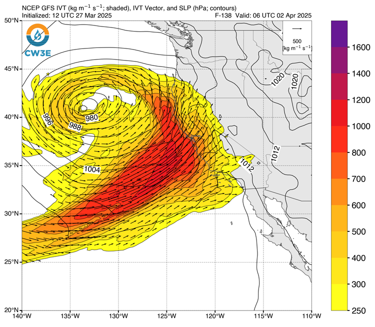
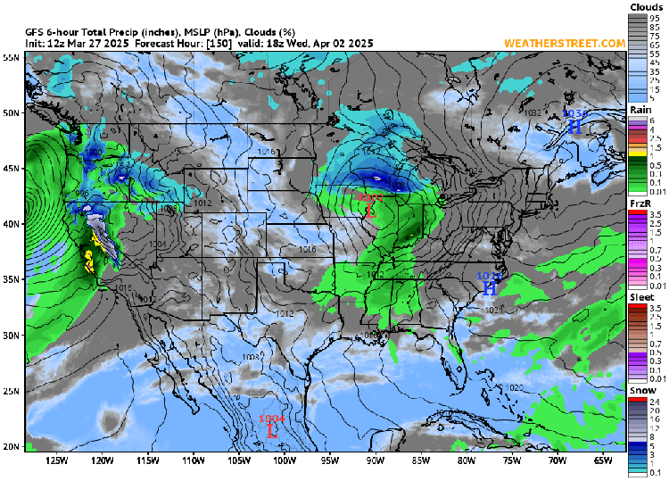
This graphic is the Integrated Vapor Transport forecast for 10 PM Tuesday night. This signature is a classic Atmospheric River (AR). It will have no problem spilling over into Western Nevada on Wednesday bringing a good amount of snow and rain. The big question is what the snow level will be. Given the tropical nature of this AR, my best guess it will be 6500 ft. or higher until the Cold Front passes, then it may drop to 6000 ft.
This is that same cloud and precipitation forecast for 10 AM Wednesday. Rain and snow will be heavy as the storm moves through the area. Plan on limited travel over the Sierra. Winds will also be strong. Likely our last storm of the season, not to say we won't see more precipitation down the road, but those storms will likely be Spring type with thunderstorms etc.
So to recap, clearing on Friday with a nice day Saturday. Sunday morning should be sunny with increasing winds and clouds in the afternoon. Stormy on Monday with snow in the Sierra and showers in Foothill and Valley locations. Brief clearing on Tuesday ???, then the AR arrives Tuesday night lasting into Thursday. Hopefully we will see clearing Friday into next weekend.
That's all for now. Take a look at the three month look ahead graphics below, looks like a mild and mostly dry Spring. Have a wonderful weekend.
Check our daily report and the National Weather Service for updates. Our daily report on our weather station site, looks 3 to 5 days ahead.
Please comment if you like on our forecasts, your own observations, or anything else. Our email link is posted below.
 |
 |
|---|
Visit our weather station site for Daily Forecasts at www.renowx.net
Contact us by sending your email to info@renowx.net